
Surveying is a procedure whose main purpose is to determine the boundaries of a particular site. It should be carried out before the registration of the territory or after making any significant changes to it. The process is implemented only by experienced professionals who have permission to this procedure. At the same time, all property owners should know what documents are needed for land surveying. The amount of securities depends on the status and purpose of the site. Additionally, the presence of neighboring plots and the reason for the cadastral work are taken into account.
The concept of land surveying
It is represented by a process designed to accurately identify the boundaries of the land. It is carried out only by hired specialists, for which citizens have to contact specialized organizations.
To conduct such a process, specialists require certain documentation from customers. You can find out exactly what documents are needed for surveying a land plot when contacting the appropriate company.
Legislative regulation
All cadastral works carried out for various land plots are implemented taking into account the requirements of the law. These include:
- the main provisions of the LC;
- Federal Law No. 221, which contains an accurate description of the process of land surveying;
- Federal Law No. 78;
- land surveying instructions approved by Roskomzem.
The Law on Land Surveying of Land indicates that if this procedure is not performed by the owners of the territory, then the land will not be inherited, and it will also be impossible to conclude any transaction the subject of this real estate.
Preparation before land surveying
It is important not only to understand what documents are needed for land surveying, but also how to properly prepare for this process. To do this, the following actions are implemented:
- necessary work is carried out on the site;
- agreement is obtained on changing borders from owners of neighboring plots;
- the owner of the territory will be determined with which organization he will contact to receive land surveying services;
- the necessary documents are prepared and transmitted to the selected specialist.
Only after completing all the preliminary steps can you begin the direct process of land surveying.

What documents are needed for land surveying?
The number of papers may vary slightly in different situations, but the following documentation is required by default:
- Passport of the direct owner of the territory.
- If it is planned that the procedure will be performed by the representative of the owner, then a power of attorney is drawn up and notarized.
- Legal documents with which you can understand how a citizen became the owner of the object, and they can be represented by a contract of sale, an act of obtaining land from the state or other paper.
- Technical documents on land, which are an extract from the USRN, cadastral plan, papers from the BTI. If there is any building on the territory, then technical documentation for this object is needed.
- A certificate confirming that there is no ban on the use of the territory.
- Application for land surveying.
Mandatory land surveying allows in the future to make various transactions with this property.All documents collected by the owner of the territory must be submitted in originals. If it is revealed that the papers are fakes or contain errors, then the survey will be denied, and it will be impossible to use the act drawn up by specialists to make changes to the USR.

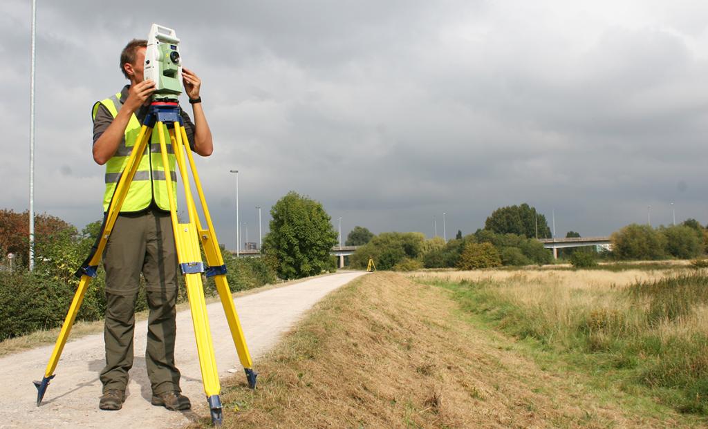
How is the process carried out?
The site surveying procedure should be carried out in the correct sequence of steps. To do this, the following actions are performed:
- an agreement is made with the selected company;
- all documents are transferred to specialists for study;
- the day is set when the expert arrives at the site to take measurements and inspect the land;
- Based on the information received, an act of land surveying and a conclusion on the work performed are drawn up;
- all official documents are transferred to the customer, after which he transfers them to the USRN to make the necessary changes to this register.
Based on the changes made, it is possible to request a new extract from the USRN in Rosreestr. Since 2017, a certificate of ownership of the land plot has not been issued, therefore, the current extract from the registry is confirmation of the introduction of adjustments.
Land surveying services are provided by different companies on a paid basis. The procedure for measuring, examining and creating documents is carried out within about one month.
What documents are prepared by specialists?
Based on the survey, the customer can receive the following documents from specialists:
- land surveying plan containing information on exactly where the boundaries of the existing site go;
- cadastral passport of the site and plan of the territory;
- plan of geodetic survey of the territory, which allows you to make an electronic plan of the object.
All these documents must be available to every owner of the site, since without them it will not be possible to conclude any transaction in relation to this object.

What if there is no title documentation?
To register a summer cottage or other territory, the owner must certainly have documents confirming his right to this object. They are represented by title documents. If there is no confirmation of the right of ownership of the land, then the survey will not work.
Under these conditions, a citizen who owns the property must go to the city’s archive or to the BTI to restore official documents.
The nuances of making a survey plan
The law on land surveying indicates that the most important document drawn up after this process is a land surveying plan. It includes the following data:
- information about the land plot represented by its address, area, purpose and other parameters;
- lists the buildings available on the territory;
- data on completed cadastral works are indicated;
- information is provided regarding measurements;
- rules for calculating various indicators are prescribed;
- personal information about the customer is indicated;
- information about the artist is entered;
- the conclusion drawn up by the engineer after inspection of all documents and the site itself is given;
- included in the plan graphics and images of the site.
It is the boundary plan drawn up by professionals that acts as the basis for making changes to the USRN regarding the size or other characteristics of the summer cottage.

Nuances for land in SNT
Land surveying of land in gardening is allowed. SNT are created to simplify the registration and use of land. To conduct the process, it is required to assign a certain cadastral number to the territory, as well as collect the necessary documents. Usually land owners in SNT do not have any land plots. In this case, you will have to deal with their recovery.
Most often, applications for surveying by several members of such a partnership are filed, which reduces the costs of the procedure.
Features for land under IZHS
If it is planned to erect a residential building on any plot of land, land surveying is required. Without it, any erected object will be recognized as an unauthorized building.
Without registration of the land plan of the land, it will not be possible to register the constructed real estate. Additionally, using this document, if necessary, you can divide the entire territory into several parts, if it has several owners.
When surveying in the territory intended for individual housing construction, standard actions are performed by selected specialists. For this, the customer is required a passport and title documents. Only after the process is completed is it possible to build an object or conclude a deal, the subject of which is a land plot.

Is neighbors consent required?
According to the Federal Law No. 221, for conducting a land survey, the owner of the territory is obliged to enlist the support of the owners of neighboring sites. This is due to the fact that they are stakeholders. Therefore, a notification containing information about the date of the survey is preliminarily sent to them.
Neighbors can be present during this process, if necessary, to challenge certain information received by a specialist. Only in this case does the possibility that territorial disputes arise between the owners of neighboring plots.
If the neighbors refuse to be present at the land surveying procedure, then a preliminary act of land surveying is formed, where the relevant information is indicated. Over the next month, neighbors must approve the boundaries. If they repeatedly ignore the notifications, then the documentation becomes legally approved without their consent.

Is surveying allowed without the necessary documentation from the customer?
Often, owners of different territories cannot confirm their ownership of this property, and also do not have different permits. They may not initially take shape or get lost in the process of time.
It will not work even without a single paper to carry out a survey. Therefore, the owners of such sites should prepare for a rather long and difficult process of restoring documentation. Basic documents can be obtained from the BTI, but often it is necessary to contact the archive of a certain region. Additionally, it will be necessary to resolve various conflicts arising with the owners of neighboring plots that have different documents for their real estate.
If a citizen does not have documents for real estate, then the process of land surveying can drag on for several months, and often takes even six months.
Conclusion
Land surveying of any territory is an important process, which is an essential stage of cadastral work. It is carried out only by specialists with the necessary skills, equipment and a license to work. The process is implemented only after the customer transfers to the employees of the selected company all the necessary documents for the existing site.
If there are no title documents or other papers on the territory, then the survey will not work. Therefore, you will have to initially deal with the restoration of documents.