
Cadastral value is used in the process of calculating property tax. Its size is determined exclusively by cadastral engineers, taking into account the technical parameters of the facility. In this case, the market price, location nuances, infrastructure or other important parameters affecting the actual value of the object are not taken into account. Therefore, often property owners are faced with the fact that the cadastral price is too high. As a result, a decrease in the cadastral value of the land plot is required. The procedure can be performed on the basis of an application filed with the Federal Service for State Registration or through a court.
How is the indicator calculated?
The procedure is carried out by the state, therefore, cadastral engineers are involved for this. The process has some features:
- held every 5 years, so this value is regularly changed;
- allowed at the initiative of Rosreestr to conduct an assessment more often;
- cadastral indicator affects the market price of real estate;
- its determination does not take into account such important indicators as infrastructure or value for potential buyers.
Due to the cadastral indicator, property tax is calculated, therefore, often property owners are faced with the fact that due to the high cost they have to pay a significant amount to the budget. Therefore, a reduction in the cadastral value of the land is required.

Tax calculation nuances
Property tax is regional, so funds are allocated to the local budget. A fee is paid by all citizens and companies that own land. It can be bought, gifted or inherited. Every year it is required to pay 0.3% of the cadastral value of this object.
Receipts are sent to citizens at the place of residence, so just pay the funds. Companies must independently calculate and transfer funds to the budget. At the same time, citizens and firms often think about reducing the cadastral value of a land plot. Judicial practice shows that if you prepare evidence that this value is overvalued, then you can count on a price reduction.
Why is the price up?
The standard cadastral value should be approximately equal to the market indicator, but in practice it often turns out that these values are completely different. Often, the cadastral value is 4 or 5 times higher than the market value. Under such conditions, the owners have to pay a really significant amount of tax. This leads to the fact that they want to reduce the cadastral value of the land.
When determining the market value, the price of similar objects, the state of the real estate market and factors that are important for the direct buyer are taken into account. When determining the cadastral value, engineers take into account the following criteria:
- attractiveness of the existing territory for investment;
- location of the facility;
- prospects for the development of existing infrastructure.
A complete list of these criteria is listed in special guidelines that engineers use.If the owner of the territory is sure that the price of his real estate is too high, then he may demand a reevaluation, the results of which will reduce this figure. But such a reduction can only be achieved if there is evidence of an unreasonably high price.
Significant discrepancies are often associated with errors made by cadastral engineers or even with confusion in the records. Therefore, it is initially advisable to order from Rosreestr an extract from the USRN on a plot of land in order to make sure that all entries in the registry are reliable.

When does the indicator decrease?
A decrease in the cadastral value of a land plot is permitted only if certain conditions are met. These include:
- there is evidence that the fertile soil layer was seriously damaged for various reasons, so the cost of land should really be reduced;
- a swamp or ravine arose in the territory;
- change in the purpose of the territory;
- the plot becomes the property of several people;
- natural disasters occurred on the territory, which led to the deterioration of land parameters;
- the type of permitted use has changed;
- the government issued a public easement for good reason.
In the presence of the above reasons, a decrease in the usefulness of the territory is ensured. Therefore, a decision may be made to reduce the cadastral value of the land. But all such situations should be officially proved, therefore, it is required to transfer to the experts various acts, title documents, extract from the USRN and other papers confirming the existence of various reasons for the decrease in the indicator.
Who is involved in the process?
Only land owners can insist on reducing the cadastral value of the land. Judicial practice shows that if there is evidence of a deterioration in the parameters of the territory, it is possible to reduce the cost even by 4 times.
If, five years after the revaluation, the value is again overstated, the owner of the territory can re-submit an application for its review.

Stages of the procedure
The procedure for reducing the cadastral value of a land plot is considered quite simple, as it is implemented in several successive actions. Initially, you should determine what the cadastral value of the existing site is, for which you can find the necessary information on the Rosreestr website or order an extract from the USRN.
On the institution’s website you can even find information about the date and rules for revaluation. If it is revealed that the indicator is indeed unlawfully overstated, the owner of the territory may change it. It is required to apply to an independent appraiser to reduce the cadastral value of the land. The cost of specialist services depends on the size and other parameters of the territory. The appraiser draws up a special report, which indicates the real price of the object.
Further, the procedure for reducing the cadastral value of a land plot involves applying to the Rosreestr with a statement. If the necessary actions are not performed on the basis of this document, a lawsuit is filed in court.
It is advisable to carry out the procedure exclusively in a situation if the available indicator is 30% or more higher than the actual cadastral price. The opinion of the appraiser is not enough, so you have to attract several experts, and all of them must be members of the SRO.

How to execute the process in an administrative way?
Initially, you should try to resolve the issue by the administrative method, for which an application with other documents is submitted to the Rosreestr branch. To do this, select the department of the institution at the location of the territory. Features of the process include:
- it is advisable to make an appointment in advance so as not to waste time waiting in line;
- a competent statement must be compiled correctly, which indicates the need to change the established indicator;
- the decision to reduce the cadastral value of the land may be negative if there is not enough evidence of the appropriateness of this process;
- the refusal is certainly executed in writing, and the document lists the reasons for such a decision.
If the cause of the failure is different technical reasons, then after correcting them, you can submit a second application. In other circumstances, you will have to file a lawsuit.
What documents are required?
When using the administrative method, it is required to transfer certain documentation and an application to the Rosreestr branch. Documents to reduce the cadastral value of the land are as follows:
- correctly drawn up statement, and it is formed on behalf of the owner or holder of the right to use the territory;
- if there are several owners, the document is prepared on behalf of one owner;
- applicant's passport;
- it is allowed to attract a representative, but it is required to draw up a power of attorney certified by a notary;
- title papers for real estate;
- extract from the USRN to the site, which can be replaced by a cadastral passport, if the ownership was issued before 2017.
If necessary, other documents may be requested allowing competent revaluation.
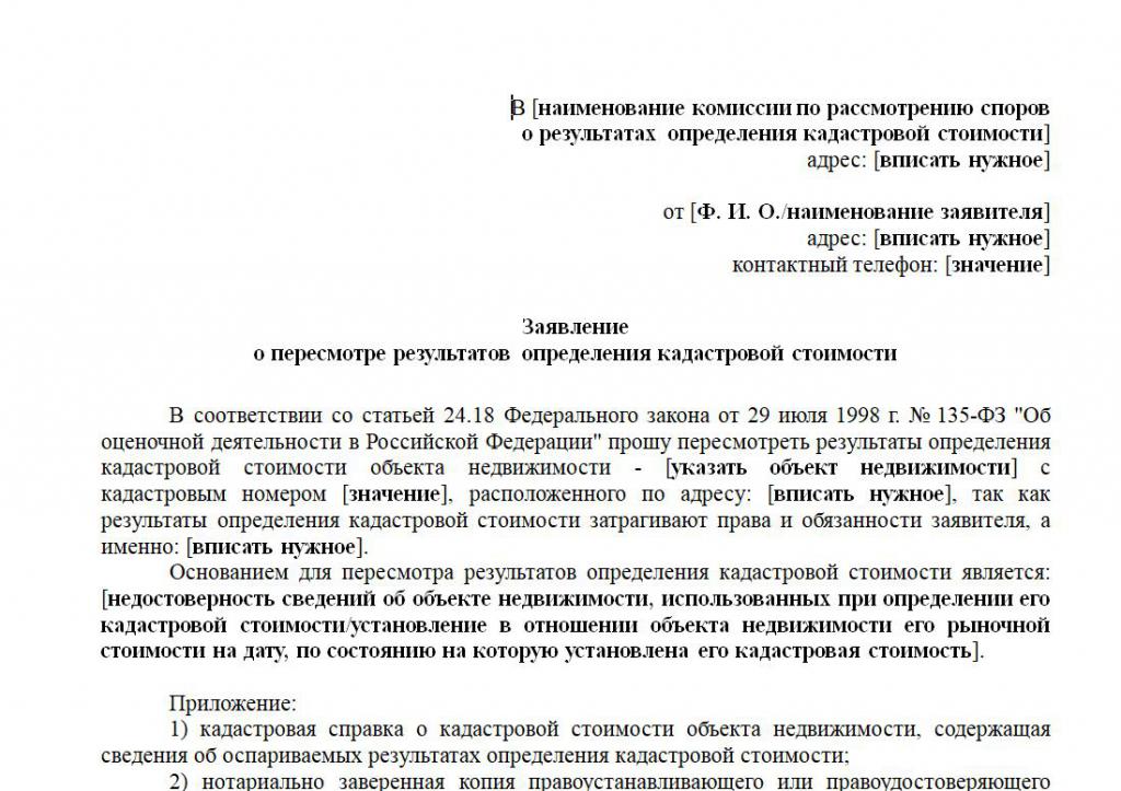
Application Rules
Most often, citizens have difficulties with compiling an application to reduce the cadastral value of a land plot. To do this, use the form of the established sample. You can get this document directly at the Rosreestr branch or on the website of this institution.
It is a statement that is considered by members of the commission when deciding on the possibility of changing the cadastral price of an object. The statement must contain information:
- personal information about the owner of the territory to which his F. I. O. belongs, place of residence, contact details and information from the passport;
- the text indicates a request to reassess the land;
- The reasons for changing the indicator are recorded.
A sample application for reducing the cadastral value of a land plot can be studied below.
As soon as all the documents and the application are ready, they are transferred to the employee of Rosreestr. He gives the applicant a receipt in the acceptance of the documentation. It also indicates the date when you can come to the institution for a written response.
Decision Dates
The decision on whether the cadastral value will be changed is made within 7 days. If there are no problems with documents, and the validity of the applicant’s requirements is confirmed, then the decision is made by the commission within one month.
If the application is not accepted for consideration, then the land owner is notified of the reasons for this situation. It is allowed to challenge the refusal within 10 days, for which a lawsuit is filed in court.
The nuances of the trial
In case of unreasonable refusal on the part of Rosreestr employees, it is possible to apply to the court with a statement of claim. The procedure must be completed within 10 days from the receipt of the decision from the commission. The plaintiff will be the owner of the territory, and the defendant - Rosreestr.
A lawsuit to reduce the cadastral value of a land plot is filed at the location of the Rosreestr branch. Other documents are attached to it:
- land valuation report, on the basis of which it can be seen that the value in the Rosreestr is overstated;
- evidence of pre-trial attempts to resolve the issue;
- title documents for land;
- applicant's passport;
- acts of inspection of the territory;
- written refusal of the commission to change the indicator;
- certificates issued by independent appraisers;
- receipt of payment of duty.
The results of a previous land plot assessment may be used to reduce the cadastral value. It is advisable to use the results obtained from various appraisers altogether, which usually positively affects the court decision.

Procedure cost
If you can’t reduce the indicator in an administrative way, then you will have to prepare for significant costs, since going to court requires the following costs:
- Attraction of an experienced lawyer - from 20 thousand rubles;
- payment for appraiser services - from 10 thousand rubles;
- receipt of extract from the USRN - 300 rubles .;
- amendments to the registry - 350 rubles .;
- payment of the fee for filing a lawsuit - 300 rubles.
Rates can vary significantly in different regions, and the size and features of the existing site also affect the cost.
If the court makes a positive decision for the plaintiff, then the size of the cadastral value is changed by force.
When do changes take effect?
After a decision is made by the court or the direct Rosreestr, the necessary information is entered into the register, after which it is published on the institution’s website. In fact, such a decision will enter into force only six months after the publication of information. That is how much time is required to update the records to Rosreestr specialists who are members of the revision committee.
Based on the changes made, recalculation is carried out, so the property tax is significantly reduced. If employees of the Federal Tax Service were not notified of the changes, then you can take a certificate from Rosreestr containing up-to-date information regarding the cadastral value of the site. After that, recalculation by the tax office will be carried out.

Conclusion
The cadastral value of the territory is used to calculate the tax on this property. Often this indicator is overstated, therefore, it is required to reduce it. The procedure may be carried out administratively or through a court. The court should only be contacted if the refusal to change the meaning of the employees of Rosreestr.
To complete this process, it is necessary to prepare the necessary documents that are submitted to the Federal Register or the court. Challenging the indicator is allowed only if there is evidence of unjustified overvaluation. To do this, it will be necessary to attract appraisers performing revaluation of real estate and compiling a report. The owners of the territory should be prepared for a certain expenditure of funds, therefore, if as a result of the process the indicator is slightly reduced, then the procedure is impractical.