
At present, the term “land surveying” cannot be found in normative acts, because it is not there. So, under it should be understood the activities associated with the establishment of the boundaries of the land. What is this procedure intended for and what is needed for surveying a site? The article is devoted to these issues.
What is land surveying?

Today, without land surveying, the owner of the land does not have the right to register it, as well as carry out many other operations and transactions. At least for this reason, the question of whether a site should be surveyed can be rejected automatically. However, in the article we will consider all the factors that a modern citizen needs to know about.
By land surveying a land should be understood as a certain pool of work related to the identification, restoration and fixing of the boundaries of the territory, its area and other data. It is also advisable to include the further formalization of the obtained indicators in legal terms, if necessary. The survey company can answer the question of whether it is necessary to make a survey of the site, because it is she who is engaged in relevant activities. The fact is that only such a structure is entitled to obtain a license permit for the implementation of engineering and geodetic operations. By the way, the answer to the question, one way or another, will be positive.
Why do I need land surveying?

It is worth noting that the main purpose of land surveying is the establishment, a clear definition of boundaries. However, the owners of land rarely implement the named procedure at will. This is explained by the fact that a certain period of time ago in establishing the boundaries of the territories there was no need at all. Then a long time period was determined by means of maps. Currently, the process of land surveying is carried out on the ground, and the cartographic option is used extremely rarely.
So, why do you need land surveying? Based on the documentation drawn up after all measurements are made, a cadastral plan of the land plot is formed. It is worth noting that without it it is impossible today to enter land into the register of real estate of state significance. But without registering the fact of owning land, it cannot be exchanged, sold, donated, leased, or a number of other operations performed. Now you know what land surveying is for. In general, this is a rather complicated process, which is regulated by a significant amount of both normative and internal documentation of cadastral engineers.
What is necessary for land surveying?

If you seriously think about the question of whether land surveying is necessary, it is advisable to start preparing for the immediate implementation of the procedure as soon as possible, without delaying this process. It should be borne in mind that the product of the first stage of determining the boundaries of land allotment is impossible without ensuring the following series of actions:
- The study of cadastral data by specialists of the corresponding profile, who, as noted above, must necessarily have a license issued by state authorities.
- The study of documentation that confirms the right to own real estate. Surveyors also perform this task.
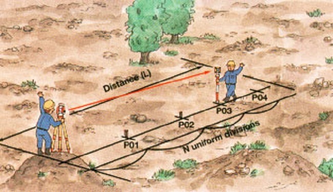
- Formation of a technical project. This manipulation occurs by arriving at the place and identifying the boundaries of the land allotment. Moreover, a geodetic survey is mandatory, and all the information received is entered directly into the land survey.
What is needed from the owner?
We figured out why land surveying is needed. However, as it turned out, this procedure is quite laborious. It is attended not only by surveyors who have special licenses, but also by property owners. So, from the owner of the land for the implementation of surveying, it is necessary not only to submit the necessary documents. Seven days before the start of the procedure, he must notify absolutely all neighbors. It should be noted that this procedure can be provided by specialists of the geodetic structure, however, for a hotel fee. In addition, the owner of the land is obliged to be present during the working process on his territory.
Procedure benefits
Before answering the question of why land surveying is necessary, it is advisable to evaluate the currently known advantages and disadvantages of this procedure. The advantages include the following points:
- The operation often acts as an assistant in the division of property complexes between two or more heirs. By the way, this is another clue for those who are in thought, whether it is necessary to make a survey. As a rule, the boundaries of land plots that are formed from one initial allotment of land are considered conditional. That is why the procedure allows you to eradicate emerging disputes.
- Why is land surveying necessary? It is important to know that it involves the protection of its land from attacks by neighbors. Some of them, being not quite decent people, can use part of your allotment and at the same time claim that the land belongs to them. Currently, in practice there are quite a lot of such cases, especially if the territory is not surrounded by a fence.
- Is land surveying necessary and practical? Through this procedure, you can increase the area of your land by 10 percent. Surely 50 percent of the population does not know about this.
- If a land survey was made on the land, then it is much easier to build housing on it.
- Why is land surveying necessary? It allows you to determine the boundaries of allotments with complex geometric shapes. Unfortunately, without the implementation of the procedure in question, this is impossible.
Disadvantages of land surveying
Before deciding on the question of whether land surveying is necessary or not, it is advisable to appropriately evaluate all the pros and cons of the procedure. The benefits we have made out. The main disadvantage of land surveying today are the costs of its implementation. In order to determine the boundaries of its territory, it is necessary to call the specialists of a geodetic company and, of course, pay for their services. For example, in the Moscow region we will talk about such a sum of money as 15-25 thousand rubles. It should be added that another minus is the duration of the operation, especially if it is produced by a structure of national importance.
Benefits for the owner

What does the owner of the land get as a result of the land surveying procedure? After all the necessary work is carried out by specialists, the owner is given a special boundary plan. It is important to note that this document consists of two parts: graphic and text. The latter contains the following information:
- Background information regarding the land.
- Data on changes in the boundaries of the territory.
- Exact coordinates and land area.
- Conclusion drawn up by the cadastral engineer and approved accordingly. It is worth considering that the signature in this case is very important.
The grafical part
It should be noted that the following information is included in the graphic part of the special land survey plan received by the owner of the land plot:
- A clear outline of allotment of land.
- Drawings of current boundaries.
- Geodetic construction.
- Schemes of objects that are built on land.
It is important to keep in mind for reference: if, after the measurements are completed, the area or boundaries of the land plot are changed in some way, the owner agrees to submit a special boundary plan to the committee on land resources.
How to replace land surveying?
Surely many today are interested in the question of whether there is currently an alternative to land surveying. Unfortunately, she never was and never is. Current legislation of the Russian Federation does not provide for other procedures. It is worth noting that in some cases it will be possible to do without revealing land boundaries. Many people believe that the land surveying procedure can be replaced, for example, with a cadastral passport. In fact, the information regarding land in the land plan and cadastral passport is the same. Nevertheless, to apply for a passport, one way or another, you need to organize the procedure and submit a boundary plan to the Rosreestr.
Is the procedure mandatory?
And finally, we will consider in which cases the land surveying procedure is mandatory, and in which it is not.
The legislation in force in Russia did not define this operation as mandatory. Nevertheless, in most cases the need for land owners arises in it, because without defining the boundaries at the present time, some actions are impossible. We have reviewed the corresponding list above. For example, it is important to establish boundaries in order to avoid disputes with neighbors or in order to find out what boundaries a land plot has, which is distinguished by a complex geometric shape.
Surveying is not always necessary
Today, in practical activities, there are several situations in which the need for a land surveying procedure does not arise. We are talking, for example, about the so-called "summer amnesty", which was introduced into use in 2006. It is important to note that the simplified registration scheme for immovable property used for gardening or horticultural purposes by citizens of the country is established by law. On the basis of a “summer cottage amnesty”, the owner can register the ownership of the land plot without submitting a cadastral passport or other technical documents to the Rosreestr.
Conclusion
So, we examined in detail the category of land surveying, its essence and the importance that is currently attached to it, determined what it is for, and also outlined the main advantages and disadvantages of the procedure. In addition, they found out whether the operation is mandatory, and gave some practical examples.
In conclusion, we characterize the main points described in the material, as well as make some conclusions that are useful for the Russian population.
So, if a land plot falls into the category of those that can be registered in accordance with a simplified scheme (in this case we are talking about a “summer cottage amnesty” described in the previous chapter, as well as some other situations of a similar nature), then it is not necessary to check : There is no urgent need. It is worth remembering that the event has a rather high cost of organization. Moreover, it is quite lengthy in terms of time. At present, the process of land surveying, as a rule, is delayed for a period of one to one and a half months (you must agree, this is not so small if you take into account the whole range of duties assigned to the owner of the land during the implementation of the operation).
The owner of the land space is obligated to ensure close monitoring so that all work operations are carried out correctly and are finally carried out, as well as the correctness of the prepared documentation.It is important to note that all documents must be properly executed and contain the information established by the legislation in force on the territory of the Russian Federation (the list of securities is presented above). Otherwise, the Rosreestr simply will not accept the documentation, and accordingly, everything will have to be redone. It is important to know that despite all the possible difficulties, it is better to carry out the land surveying procedure, if possible, because a number of pluses are hidden behind several disadvantages.