Cadastral number of the land plot, which can be found in several ways, is a unique, non-repeating set of numbers in the territory of the Russian Federation and in time. It is given to each registered property. You can get the cadastral number of the land after the procedures established by law. 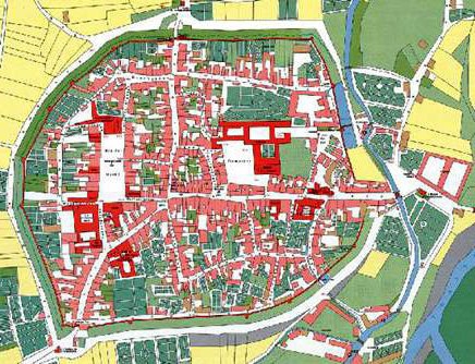
General order
The assignment of a unique number is carried out after cadastral and inventory (technical) accounting. The resulting set of numbers is stored for the entire period while there is a single object with registered right. In the Federal Law governing the state registration procedure, identification by conditional number is allowed in the absence of a cadastral. It is given to the object when accounting for the object in accordance with the regulatory act of the federal executive body. Along with this, the identification of the land is carried out exclusively by cadastral number. It, in turn, is given by an authorized body in this area. 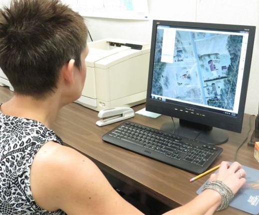
Assignment of a cadastral number to a land plot
The procedure in accordance with which this procedure is carried out is established in the rules. They are approved by Government Decision No. 660 of September 6, 2000. A map of cadastral numbers of land plots is formed when dividing the territory into quarters. Each of them has its own set of numbers. It includes the cadastral number of the county and district. Each allotment formed and subject to registration as real estate, the rights to which must be registered in a single register, must be given a unique set of numbers. If the owner has several separate plots that are presented as a single land use, the owner can declare them as an indivisible object with the assignment of one number. Before entering data on the allotment in the registry, documentation is checked. It includes papers on surveying previously considered objects and conducting cadastral works on the basis of an application. The latter, in particular, include redistribution, separation, merger, allocation. 
Territorial unit
All cadastral districts are divided into districts. Within these parts of the territory, allotments and maintaining the state register are carried out. As a rule, the cadastral region includes the administrative unit of the subject. The waters of the territorial sea and inland waters can form independent parts. The smallest unit of the cadastral district is the quarter. A separate registry key is opened on it. It contains a map of cadastral numbers of land plots. Typically, the quarter includes small settlements, the territory of a settlement or urban development, and other areas limited by artificial or natural objects.
Counties
The law provides that the procedures in accordance with which the division of the territory of Russia, the assignment of numbers to objects is carried out, must be established by the body authorized to carry out regulatory regulation in the field of land relations. Currently, the relevant procedures are carried out in accordance with Order No. P / 9 of May 14, 2001. According to its provisions, 89 districts were formed in the Russian Federation according to the scheme of their location, the list of names and numbers. For example, Adygea - 1, Bashkir - 2 and so on. 
How to find out the cadastral number of a land plot?
As a rule, the owner knows a unique digital set belonging to his object. However, in some cases, information about real estate owned by another person is needed. It still happens that the owner of the allotment does not know what the cadastral number of the land is. You can check it, knowing at least roughly the address where the object is located. There are several ways to find out the required information. The most popular is the search for information on a public map. It should be said that the data is available only for those plots that have a boundary plan. The cadastral map contains a simple and advanced search. The latter should be activated. Next, select the "By address" tab. In the drop-down list, the subject of Russia is indicated, then the municipality, then the settlement (village). After all the information has been entered, you need to click on the "Find" button. The window will automatically switch to the appropriate area. Next, you should manually zoom in the map until the borders of the plots are displayed on it. Among the contours that appear, you need to find the allotment of interest. However, in some cases it can be difficult to do. Before you find out the cadastral number of the land, you should open the "Management" menu at the top right and select "Satellite Images". In this case, the window will switch to satellite display, and it will be easier to determine the location of the allotment. After the object is found, you need to click on it with the mouse. Information about the allotment will appear, including the cadastral number. 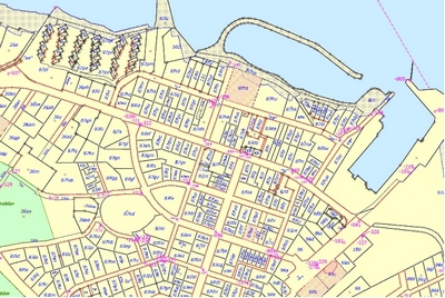
Portal Rosreestra
This is another way by which you can determine the cadastral number of the land. Checking the information in this case will be somewhat more difficult than with the above method. Rosreestr does not contain graphic material. In this regard, it will be necessary to find out the information by selection. Before you find out the cadastral number of the land, you should establish the address at which it is located as accurately as possible. The more accurate it is, the more likely it is to find out the required information. On the portal Rosreestra should fill in the menu field "Address". In the column SCN / USRP, you must select the sources from which the data will be used. This can be a register of rights or a state real estate cadastre. From the drop-down list, the subject, district, type and name of the settlement are selected. Street, house and apartment number are filled in manually. Next, confirm the entered data and send a request. As a result of the search, the most suitable objects will appear. 
Other options
Are there other ways to find out the cadastral number of a land plot? You can find out the information by having the relevant documents on the allotment. First of all, the number is put in the cadastral passport. One copy of it upon registration must be transferred to the owner. But it happens that from the accounting date the assignment order of numbers can change. In this case, you will have to order a new document. To do this, contact the MFC or form an electronic request on the Rosreestr portal. The application should indicate the location of the object.