The Northern Sea Route (NSR), its development and development, is of great interest to scientists, researchers of our country and foreign experts. His story is about interesting expeditions, amazing discoveries and, of course, amazing people who devoted their lives to the study of this path.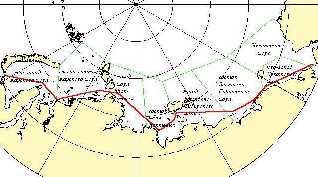
Geographical position
This name was given to the Northern Shipping Route, which runs along the seas of the Arctic and Pacific (partially) oceans. These are the Kara, East Siberian, Barents, Bering and Chukchi seas, the Laptev Sea. The Northern Sea Route runs along the coast of Siberia. The routes connect Russian and Far Eastern ports, the mouths of Siberian shipping rivers into one transport system.
NSR limits the western entrances to the straits, as well as the meridian, which stretches north of Cape Zhelaniya. And in the east - the Bering Strait. The length of this sea highway is 5600 km.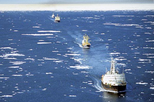
Ports
The main ports of the Northern Sea Route:
- Dudinka;
- Dixon
- Igarka
- Pevek;
- Tiksi;
- providence bay.
Today, work is underway to implement a project to transform the port of Petropavlovsk-Kamchatsky into a port hub on this route.
It occupies a very advantageous position, which allows it to become an important transport hub on this sea highway between the Asia-Pacific region and Northern Europe. In addition to its favorable position, the port of Petropavlovsk has other advantages - ice-free bay, year-round navigation, the ability to store, accumulate, and also sort container cargoes.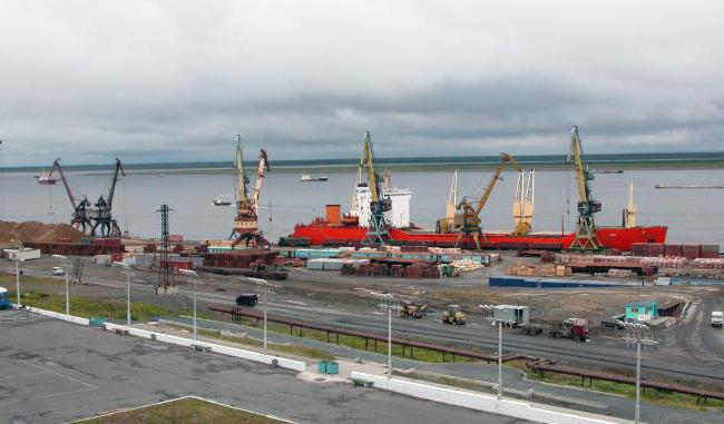
In recent years, the ports of the Northern Sea Route have been actively reconstructed and modernized. This allows you to increase their ability to receive large international vessels.
Dudinka
This is the northernmost sea (international) port in our country and the largest in Siberia, which is located in the Krasnoyarsk Territory. An interesting fact - Dudinsky port is the only one in the world that is flooded annually during the spring ice drift.
It is managed by Norilsk Nickel, a branch of the Russian mining and metallurgical company. It is used as a sea and river port. Located on the right bank of the Yenisei, where the mighty river merges with Dudinka. The port connects the cities of Talnakh and Norilsk by road and rail.
North seas
The Northern Sea Route begins in the waters of the Barents Sea, and ends in Providence Bay. It should be noted that all the seas of this shipping line have a harsh climate. Judge for yourself. In mid-July, the air temperature on the coast of the Barents Sea does not exceed +7 ° C, and in winter it drops to -20 ° C. This sea is characterized by frequent gales. The height of the waves reaches 7 meters.
On the coast of the Kara Sea, summer air temperature does not rise more than +6 ° C, and winter temperature reaches -28 ° C. In the summer, northern winds are noted, which are usually accompanied by fogs. In winter, they are stronger and more frequent, often turning into hurricanes.
The climate of the Laptev Sea is even more severe. In the northern part of its coast, the temperature in July is +1 ° C, in winter it drops to -34 ° C. The winds are weak.
All seas of the Northern Sea Route are characterized by small plus temperatures in the summer. The East Siberian Sea is characterized by a monthly average summer temperature of +7 ° C, and winter - up to -33 ° C.
The seas of the Northern Route have a shelf area, the depths of which are less than two hundred meters. Their bottom is an underwater continuation of the platform structures of the land. The transition zone is a continental slope, having depths from one hundred eighty to three thousand meters.
Features of the Northern Route
The characteristic features of this shipping line are the presence of ice on the entire route of transport and the harsh climate. The ice situation in some sections of the tracks has significant spatial and interannual variability. In winter, the Northern Sea Route covers the anticyclonic circulation of air masses. In summer, atmospheric circulation is the opposite of winter, but its impact on the climate is not so great.
History of the Northern Sea Route: pioneers
According to historians, Novgorod people came to the Cold Sea in the 11th century. In 1032, the Dvinsky posler Uleb mastered the first Northern Sea Route to the Kara (Iron) gates of Novaya Zemlya. He was unable to enter the Kara Sea, as his ship was not able to move in the ice.
In search of new products for the markets of Novgorod, the brave seafaring sailors moved further north. At about this time, the sea route was opened to Grumant, as well as to the islands of Vaigach, Novaya Zemlya and Kolguyev. Pomors on their bumps were the first to discover the majority of Arctic lands, therefore it can be stated with confidence that they began to develop the Northern Sea Route.
Expeditions of foreign sailors
Trying to find a passage to the coast of South and East Asia in the north, in the second half of the XVI century the British sailors went on an expedition. From 1553 to 1580, they went on sea trips three times, wishing to pass through the Arctic seas to the Pacific Ocean. The first two expeditions managed to get to Novaya Zemlya. The third expedition turned out to be more successful - it entered the Kara Bay, but a huge accumulation of ice forced the brave sailors to deploy the ship and return.
At the very end of the same century, the Dutch became interested in implementing this idea. They managed to reach Yamal in 1594. The expedition consisted of four ships. A year later (1595), already seven Dutch ships sailed into the Kara Sea, but again they had to turn back. Only the third expedition (1596) happened to discover the coast of Svalbard and the Bear Island, and then go around the New Earth from the north and enter the Kara Sea.
Unfortunately, the vessels of these sailors were crushed by ice, and they were forced to winter at a latitude of 76 degrees c. w. In the summer, they went south in boats, where they were picked up by Russian sailors who brought travelers to the city of Cola. It is interesting that in the reports of the Dutch and British it is mentioned that the Kara and other seas from the Arctic Ocean were already known to Russian travelers by that time.
Research
For the first time, the assumption of the possibility of using the (practical) Northeast Passage (it was called so until the beginning of the 20th century) was voiced in 1525 by Russian diplomat and politician Dmitry Gerasimov. Theoretically substantiated the feasibility of developing this transport line M.V. Lomonosov. D.I.Mendeleev worked a lot on this topic, and he devoted more than thirty works to the development of the Far North. He worked closely with the legendary Admiral S.O. Makarov.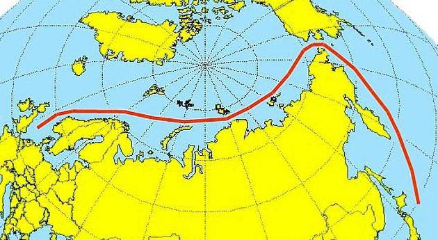
On April 17, 1732, the Russian Empress Anna issued a decree according to which she instructed V. Bering to go to Kamchatka to explore new lands that lie between Kamchatka and America, and to explore the coast of Siberia.
It was the beginning of the II Kamchatka expedition. Much later they began to call it Great Northern. She had no equal importance in fulfilling tasks in world history. It was attended by 977 people - brave ascetics. Unfortunately, many of them died in the northern ice, but the results of their work cannot be overestimated. They managed to survey and map (for the first time) the entire Russian coast of the ocean. Seven detachments spared no effort, doing their job, which today can be called heroic without exaggeration.
Then there were several more Arctic expeditions: C. Baer, F.P. Litke and P.I. Kruzenshtern.The result of these sea voyages is a firm belief that the Kara Sea is unsuitable for shipping. K. Baer even said that this is a real "ice cellar."
Nevertheless, the fishing resources in the Barents Sea were gradually depleted, which forced sailors and industrialists to enter the Kara Sea more and more often. Episodic expeditions for the export of Siberian wood, furs, gold and gems to the central part of Russia and abroad began to be carried out since 1877. Russian merchants began to invest heavily in establishing shipping and exploring the northern seas.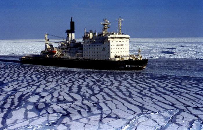
As a result, already in the first half of the 90s of the XIX century, the myth of the impossibility of shipping in the Kara Sea, which was prevailing in those days, was refuted. Since 1911, annually flights were made from Vladivostok to Kolyma of one ship. True, these campaigns did not receive development, which was explained by the lack of development of the route. The Swedish expedition of the famous explorer Nordenskjöld on the Vega barge in 1879 went all the way along the Northern Route with one winter.
Industrial surveys
The advent of the steam fleet, the invention of radio, and the construction of icebreakers became important milestones, thanks to which the northern highway was further developed. The Northern Sea Route again attracted the attention of scientists and researchers. Since 1921, the Kara expeditions were resumed, and from 1923 flights from Vladivostok to Kolyma began to be carried out.
In 1923, the first polar station (Matochkin Shar Strait) began operations in the Soviet Union. In 1924, reconnaissance and survey of ice from the air began to be regularly conducted. In 1932, the legendary expedition of O. Yu. Schmidt took place. For one navigation for the first time managed to overcome the entire Northern Sea Route of Russia.
SNK of the Soviet Union on December 17, 1932 published the Decree on the establishment of the Glavsevmorput. Since that time, this day is the date of the official opening of this highway. Research in the Far North has become regular and more focused. The first major transport operation took place in 1935. It was carried out by timber carriers “Iskra”, “Vanzetti” from Leningrad to Vladivostok.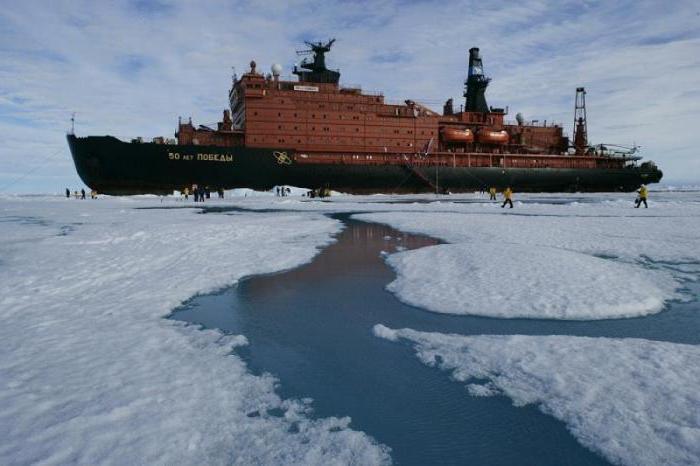
In 1936, the destroyers Voikov and Stalin marched from Kronstadt to Vladivostok. The passage took one navigation. This has become an important historical event. It allowed to strengthen the Pacific and Northern fleets. Now you can quickly transfer ships from fleet to fleet.
War
During the Second World War, the Northern Sea Route was extremely important for the Soviet North. Warships were conducted along it, the fleet was provided with coal, and the country's industry was supplied with copper, timber, and nickel. On this way, during the war years, under the protection of the military ships of the Northern Fleet, more than 4 million various cargoes were transported.
International shipping
The first foreign ships mastered the Northern Sea Route only in 1991. True, at that time it did not become a start to its widespread use. The reason was that the coastal route, due to the large number of narrow straits and shallow water, was inaccessible to large-tonnage vessels, and navigation along transit routes largely depends on the state of the ice situation.
Nevertheless, despite certain difficulties, the popularity of this path is constantly growing. For example, in 2009 only two vessels (commercial) passed through it, by 2011 there were already more than thirty of them. According to long-term forecasts, cargo transportation will reach 35 million tons per year by 2020.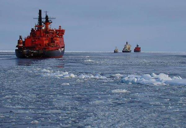
The increase in traffic flows through the NSR will require further efforts not only in the field of science, but also in the field of expanding the naval presence of Russia in this region.
The Northern Way Today
It should be noted that at the beginning of the XXI century the Northern Route became very attractive for many companies that transport sea cargo.Previously, the main transport artery for delivering goods from European regions to the Far East was the route through the Suez Canal. About eighteen thousand ships passed through it during the year. At the same time, the number of vessels sailing along the Arctic route was estimated at only dozens.
But recently, the situation around the Northern Route has begun to change rapidly. A positive factor that draws attention to the NSR is global warming. Over the past three and a half decades, the area of ice in the Arctic has almost halved. As a result, the navigation period in the northern seas has significantly increased. If earlier navigation lasted from July to September, today - from June to November.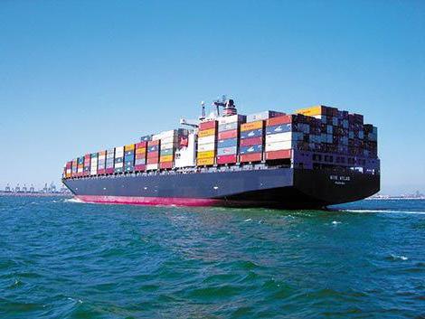
In addition, several factors should be taken into account that are capable of attracting the attention of foreign companies to this highway in the coming years:
- On average, the delivery time through the Suez Canal is forty-eight days, and the journey through the Arctic seas takes thirty-five days. Consequently, delivery times are significantly reduced, fuel is saved, and transportation costs are reduced.
- There are no queues and fees for the passage of ships (unlike the Suez Canal), there is only an icebreaking fee.
- Lack of illegal actions. Somali and other pirates off the coast of Africa attack ships.
- There are no restrictions on the size of ships and tonnage. (The Suez Canal allows the advancement of ships no more than 20.1 m).
Nordic Development Plans
The Russian government has adopted a comprehensive project of the Northern Sea Route (development for the coming years). It was signed by Russian Prime Minister Dmitry Medvedev. Approving it, the head of government emphasized that the NSR, which is the shortest route connecting the Far East with Europe, including the entire Asia-Pacific region, western North America, is currently not fully used.
The report noted the section of the project, which provides for the interests of the Ministry of Defense. It ensures the security of the country and the NSR. This route gives Russian ships free access to the Arctic and Atlantic oceans.
Today, the duration of navigation along this route is 4 months. It carries timber, gas and oil mined in the north, 90% nickel and more than 65% copper. So there are no questions about the advisability of developing this sea route.
Significance of the Northern Route
Today it becomes obvious how important this sea route is for our country. Its importance as a unique transport artery is determined by the needs of the functioning of economic complexes, industrial development of the Arctic coast. This is the most important factor in stabilizing and ensuring national geopolitics and economic security country.
This internal sea route of our country plays a huge role in the economic life of many regions of the country, which are connected with the Arctic Ocean by large rivers (Yenisei, Ob, Indigirka, Lena, Khatanga, Kolyma, etc.). No less important is the Northern Sea Route lies in the development of transport links and the economy of the north-east of Russia - Chukotka, Magadan Region and the Republic of Sakha (Yakutia). Today they account for the bulk of the extraction of gold, diamonds, tin, iron ore, coal and other minerals.