Land surveying, being one of the land management procedures, includes a certain set of works. They are carried out to restore or consolidate, as well as establish limits, determine the location and area of territories allocated to the ownership of citizens. Upon completion of these works, a boundary plan is drawn up. land boundaries. This technical document is drawn up on the basis of the cadastral scheme or an extract from it about the appropriate allotment. Let us further consider how a land plan is drawn up. An example document will also be provided in the article. 
general information
A land plot boundary plan is necessary to determine the exact coordinates of the allocated territory on the federal cadastral map. Along with this, you can determine the allotment limits directly on the ground. All information received in the course of the work is recorded in the boundary plan. The formation of a land plot without this will be conditional. In this case, it cannot be outlined graphically. Accordingly, it cannot be entered in the register. If the owner does not have a land plot boundary plan, the owner will not be able to obtain a cadastral passport. Without it, in turn, it is impossible to register an allotment in Rosreestr, which does not allow to make any transactions.
Design specifics
Only competent organizations are entitled to draw up a land plan for a land plot. Cadastral engineers should work in them. If the land survey plan is compiled in electronic form, it, like a paper copy, must be certified by the signature and seal of the specialist conducting the work. The document includes several parts. 
Sample land plot plan: graphic block
This part reflects information on the specific territory allocated to ownership. The data is in the cadastral documentation or extract from the scheme. In the graphic part, the boundaries of one or several sections are depicted or refined / restored. In the same section, access to the formed plots should be shown. This can be an entrance, a passage from those sites that are considered common. Accesses should be displayed even if they are set by easement.
Text part
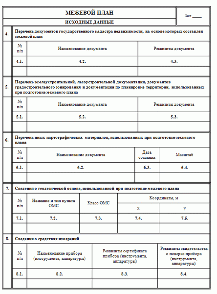
In this block of the survey plan there is information necessary for entering into the inventory. The volume in which the necessary information should be presented is determined by the authorized authority for regulatory legal regulation in the field of cadastral relations. In a number of cases stipulated by law, boundary plans should include acts of coordination of the location of the borders of the respective land territory. All necessary work is paid by the person who orders the documentation. The cost of the boundary plan will depend on the allotment area, form of ownership, the amount of data that will be entered into the inventory, as well as the need for additional services by the engineer. 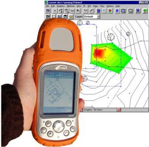
When is a document needed?
As mentioned above, a boundary plan is needed for various transactions with the land. In particular, this may be a lease, sale, gift, exchange, legal registration of the rights of the owner, association and division, and so on. Without a document, no land transactions can be made. Engineers restore the boundaries of the allocated territories in the event of disputes, as well as the loss of the relevant signs on the ground.Surveying is also carried out during the selection, division or merging of sites.
List of documents
For land surveying, the following papers are submitted:
- Statement.
- Certificate of registration allotment.
- Title documents. They are a court decision, the property of the inheritance, the decision of the authorized bodies, and so on.
- Identity document for individuals, registered papers - for organizations.
- Cadastral plan of the territory or statement.
- Documents BTI for buildings located on the ground.
The above list is not exhaustive. In each case, additional documents may be required.
Working process
To conduct land surveying with the subsequent preparation of the plan, the cadastral engineer carries out a number of mandatory measures. Typically, the scope of work includes:
- Collection and analysis of the necessary information about the allotment for which the documentation is compiled.
- Notification of organizations and citizens whose interests and rights may be affected by the intended work.
- Coordination with all interested parties of the boundaries and other points regarding the site.
- Geodetic survey.
- Processing and analysis of information received.
- Preparation and preparation of a plan.
- Submission of documentation to the authority that performs cadastral registration.
- Obtaining a passport and statement indicating the exact coordinates of the allotment for which work was performed.
The drawn-up boundary plan must be certified by a seal and signature (electronic, if drawn up in the appropriate form) by the cadastral engineer.
Stakeholder Approval
As mentioned above, the cadastral engineer sends notifications to all interested parties. The result of agreeing on the location of the boundaries of the site is drawn up by a specialist in the form of a special act on the back of the graphic part of the boundary plan. In the event of a dispute over the definition of the boundaries of the territories, the owner who does not agree with the option proposed by the engineer has the right to go to court and file a corresponding claim. Based on the situation, he can provide his own border-setting scheme. At the same time, he must justify his position. If necessary, the court may order a re-examination. 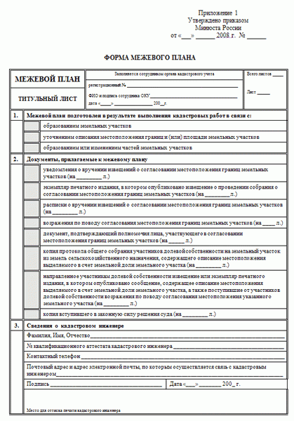
Finally
As a rule, in practice there are no difficulties with the preparation of a boundary plan if the neighbors reach an agreement. The duration of the engineer’s work will depend on the complexity of the situation, the characteristics of the territory, the number of issues that he must decide upon the request of the customer. In any case, each owner of the land should have a boundary plan so that later it can be registered without problems.