Since the time when citizens got the opportunity to take ownership of land, disputes regarding the determination of their use and division have become more frequent. These claims are essentially different. Common in them is the object - the earth. Moreover, the form of law on the basis of which affiliation is established does not matter. It can be expressed in perpetual use, property, inherited lifetime possession. Disputes arise, as practice shows, in connection with the plurality of owners in one territory. The division of shared land involves certain difficulties. In itself, this form of ownership provides for the coordination and expression of will of each owner to use the allotment. In practice, realizing this right is very problematic. Next, we consider how the division of the land occurs. 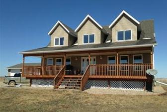
Common Property Education
It is possible solely on the grounds provided by law. For example, this may be property that is acquired in marriage by spouses. How is the formation of common property? The process, in general, is simple. Parents, for example, leave their property - a house with land - as an inheritance to the children. One comes into law by testament, and the second - on general grounds. When registering an inheritance, each of them is entitled to its own share in the common ownership of real estate. This method is considered the most common. The share of each heir is calculated in court or by a notary.
Important point
The legislation adopted certain restrictions on the inheritance of common property. In particular, the transfer of property in the form of physical indicators is considered unacceptable. This means that the owner cannot bequeath to one garage, to another - a house, to the third - land. In any case, the inheritance is considered to be transferred in shares that correspond to the value of the specified parts.
Transaction specifics
The primary feature that the process of dividing land has is the primary definition of a part for each of the participants in these legal relations. Only after that further manipulations are possible. After determining the primary share, the owners can actually allocate their share in kind and terminate shared ownership. 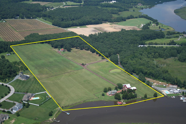
Background
The following reasons are distinguished for which the division of property may occur:
- A land plot can act as an object of sale or gift.
- An appropriate court order has been adopted.
- Share ownership ceases.
- Heirs receive a part of the territory laid by them.
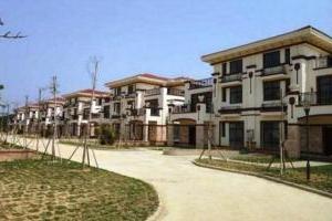
Recently, the most popular is the division of a large area of land - several hectares. This is due to the need to create a cottage village and subsequent sale to new owners of buildings and plots. A section of a land plot may constitute an allotment of agricultural land at the expense of shares.
Limitations
The indivisibility of the site is the main obstacle that does not allow the separation of parts. A territory is recognized as such if it is located under an immovable object, for example, an apartment building, industrial building, office building and other residential and non-residential structures. In this case, it is impossible to allocate a separate room in an immovable object together with a part of the land located under it.
Size Limits: General
They are set in accordance with specific land use goals. These standards severely restrict the maximum and minimum sizes of plots. For example, the owner has a plot of six acres and wants to divide it into exactly three parts for sale. However, in accordance with the norms determining the maximum size, a minimum of 3 acres is set for its territory. Therefore, it is possible to divide the land into two. Otherwise, the educated units will not be recorded in the cadastre, and therefore they cannot be registered in ownership. 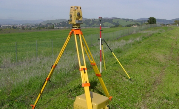
Maximum and minimum
Limit sizes for conducting country construction, gardening, horticulture, peasant farming are established in the laws of the constituent entities of the Russian Federation. The maximum and minimum values of allotment areas for the construction of private residential buildings and personal management (LPH and IZHS) are determined by regulatory acts of local governments. So, the law in the Moscow region, for example, establishes the following minimum sizes of plots by type of permitted use (in hectares):
- For gardening - 0.04.
- For suburban construction and gardening - 0.06.
- For conducting peasant-farm farming - 2.
Required documents
Section of a land plot is carried out upon presentation of:
- Cadastral passport.
- Certificate of ownership of the allotment.
- The act of determining the address of the sites.
In the absence of one of the above documents, an agreement on the division of the land plot cannot be signed.
Requirements
The newly formed plots obtained after the implementation of the division of the common territory must comply with the requirements. In particular:
- The total area of the formed parts should not differ from the size of the original territory.
- All sites formed must have one type of permitted use. At the same time, it must coincide with that which was in the common territory.
- The area of each newly formed site should not be less than or more than the limit norms established by local authorities.
- All formed plots should have direct access to public areas.
Trial

In the course of it, a decision is actually made on the division of the land or determining the procedure for its use. Cases of the second type are considered the most difficult in judicial practice. The lawsuit on the division of the land is a statement that contains a request for the provision of parts of the territory to the owners in kind. As a result, several immovable objects are formed instead of one. This section serves as a way to terminate shared ownership. Initially, it is expressed as a fractional number: 1/2, 1/5, 1/67, and so on. For example, if a land plot and a residential building located on it are rightfully owned by four owners, then each of them accounts for 1/4 of the total property. When counting the parts, it must be taken into account that their total amount should be equal to 1.
Legal basis
Allocation of the owner's share in kind is provided for by the Civil Code. The right to terminate common ownership may be exercised by all those who could not come to a voluntary agreement on the order and method of using the territory. This is regulated by the provisions of Art. 252 GK.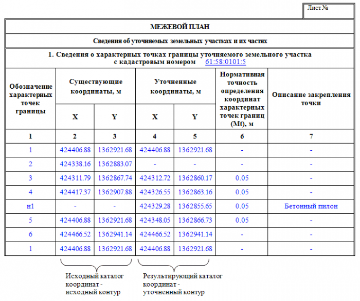
Basic conditions
When resolving land disputes, the judiciary proceeds from the size of shares in common law. Deviation from the values is allowed only in case of assignment of monetary compensation. In a voluntary division, entering into a contract or agreement, the parties are entitled not to adhere to certain sizes of shares. In this case, the principle of freedom of contract applies.
Expertise
Issues related to the allocation of parts in kind and the division of territories require special knowledge. In this regard, it is customary to use the services of qualified specialists.In particular, experts are involved who carry out land surveying. It should be said that the courts do not consider cases in which there is no expert opinion. 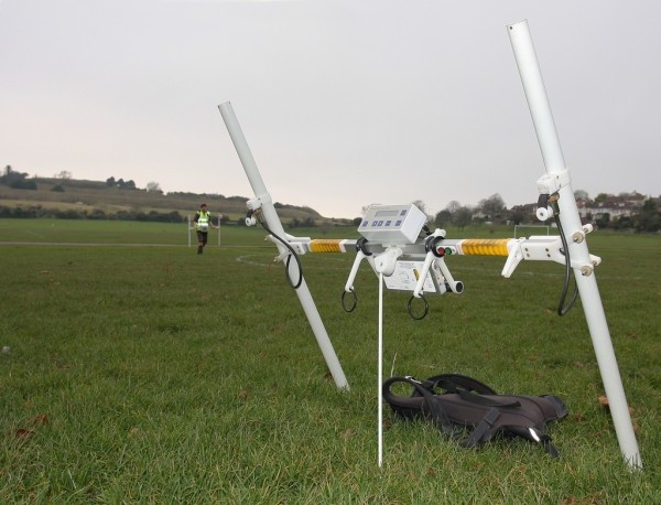
Section of the land: boundary plan
Upon the termination of common property rights, a set of measures is taken to establish and fix the boundaries of the territory on the territory, as well as determine its area and location. Land surveying of land is carried out by design and survey organizations, as well as legal and civilians with the appropriate licenses.
Event Content
Land surveying includes:
- Preparatory activities for the collection and study of cartographic, geodesic, title and other primary documents.
- Field study and assessment of the state in which the points of the geodetic state and boundary support networks are located.
- Drawing up a technical design.
- Field inspection of the boundaries of the delimited area with the determination of the state of the boundary signs.
- Notification of owners, users, owners of the plot of the proposed work.
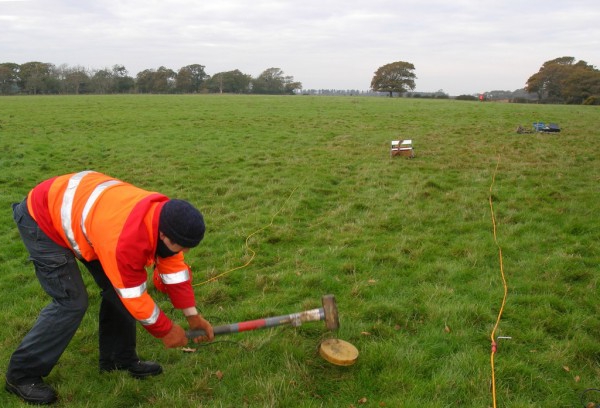
- Coordination, establishment and fixing on the ground with the help of boundary marks of the new boundaries of the site with all participants in the event.
- Allocation area determination.
- Drawing up a drawing on the borders of the territory.
- Supervision of performance and reception of results.
- Creation of boundary business.
- Sending materials to the archive.
Technical project
When carrying out the above work, a boundary plan is drawn up. It includes:
- The text part.
- Material calculations and cost estimates
- Graphic information.
The text part contains:
- Goals and grounds for the performance of work.
- Data on the geodetic basis.
- Information about boundary work performed earlier.
- Technology of geodetic measures and fixing new boundaries.
- Dates and organization of land surveying.
The boundary plan also contains a layout drawing. It is compiled on a scale convenient for work. It reflects linear and angular parameters for geodetic measurements, signs, numbers and names of shared and adjacent sections and so on.
Owner Notice
It is carried out no later than two days before the start of work. Owners and owners are notified of the date and time of the event. Notifications are given on receipt, indicating the time. Notices and receipts are drawn up in two copies, one of which must be filed to the case.
Setting and harmonizing limits
The definition of boundaries is carried out directly on the ground. At the same time, representatives of the district, settlement (city) or rural administration, the owners (owners) themselves or users of the land plot and its neighboring areas or their representatives should be present. The powers of the latter should be confirmed by a power of attorney issued in the prescribed manner. After the procedure of coordination and determination of borders is completed, they are fixed on the ground using boundary marks of the corresponding sample. The results of these events are documented in an act. It is signed by users, owners, owners of the land to be demarcated and adjacent to it, or their representatives, land surveyor, administration. The act must be approved by the appropriate committee of the city (district). 
Special cases
Quite often, in practice, courts have to consider cases on the division of plots that are allocated for the construction of private houses or cottage construction. All events with allotments in such cases also affect immovable objects located on them. Please note that the section of the building itself is possible in the legal plan without affecting the site. This often happens in practice. At the same time, it is impossible to carry out the division of the site without affecting the structure located on it.It is impossible to isolate part of the allotment in kind and leave the structure in common ownership.